There were some significant route variations between my two C2C crossings: some determined by the climate, others by inexperience.
Our earlier crossing was in often appalling weather and saw us generally choosing lower level routes: going around the High Street ridge by Ullswater, Moor Divock and paths along the Lowther valley; taking the Nateby to Keld road across the Pennine watershed; ambling along the valley route through Swaledale.
On our second crossing we varied the way through Ennerdale, selecting the path along the north shore of Ennerdale Water and that along the River Liza (much better than the trudge along the forest road). With good weather we tackled the glorious walk along the ridge above Easedale, climbed over Kidsty Pike and explored the high level route above Swaledale, through the old lead workings.
On the first C2C there was much more road walking between Orton and Sunbiggin Tarn and, if my recollections are accurate, a little more on the traverse across the Vale of Mowbray.
This time, weather, stamina and inclination permitting, I hope to be a little more adventurous. The following are variations I’ll consider when on the ground (and, in the case of the more demanding routes, maybe reject):-
1) Leave the Ennerdale valley by the path up to Scarth Gap, afterwards continuing over Haystacks to Honister.
2) At Greenup Edge leave the main route and proceed to Grasmere via High Raise, Sergeant Man and Blea Rigg.
3) Take the St Sunday Crag route over to Patterdale. The Striding Edge alternative is probably pushing my tolerance of exposure too near the limit.
4) From Rampsgill Head aim for the Haweswater shore at the Measand Beck outlet (via High Raise, Low Raise, Long Grain and Measand End). It appears, after some discussion on the C2C forum, (hosted on the Sherpa Van site) that this route is viable and carries a faint track. As a bonus there is a small saving in distance and it avoids much of the rather tedious walk along Haweswater.
5) In the section between Shap and Kirkby Stephen I may follow an approximation of Wainwright’s original route (A Coast to Coast Walk, First Edition) over the Orton Fells, from the B6260 road to Sunbiggin Tarn, crossing what is now open access land. There is no distance saving, and there may be a time penalty, but a contributor to the C2C forum recommends this option as by far the most interesting.
6) Similarly the onward route, following Wainwright’s original way from Sunbiggin Tarn, by Rayseat Pike, to the Mazon Wath/Newbiggin lane, crosses what is now Access Land. This would avoid a fair bit of road walking and saves some distance on a long day.
7) On the two occasions I’ve walked over Nine Standards Rigg to Keld I’ve used the Whitsundale Beck alternative. I’d like to vary this by going by Ney Gill, but I guess I’ll take whatever is the recommended route on the day.
8) Having walked both suggested routes between Keld and Reeth I’ll probably take a low route, but vary the walk by crossing to the south bank of the Swale at Gunnerside and improvising an onward route using lanes, tracks and available field paths.
Monday 30 June 2008
Sunday 29 June 2008
Sunbiggin Tarn to the Mazon Wath Lane

Monday 23 June 2008
Walk Itinerary
I assumed that the C2C's accommodation bottlenecks would be at Keld and Ennerdale Bridge. Lodgings were secured at Keld before I booked leave from work and got down to planning the walk in earnest. Ennerdale was less critical, I reasoned, being within a reasonable taxi ride of larger towns; in the event lodgings were quickly secured in the village.
What I didn't anticipate was the shortage of decently priced rooms in Grasmere, other than Hostels. Even booking three months in advance it took four or five emails before finding a vacancy at the Glenthorne Guest House. Although it wouldn't have been a killer blow to either pay through the nose at a classy hotel, or catch a bus to Ambleside, the hiccup did come as a surprise.
The remaining itinerary was settled without any difficulty.
| Date of Arrival | Location | Accom. |
| 04 September | St Bees | Tomlin GH |
| 05 September | Ennerdale Bridge | Cloggers |
| 06 September | Rosthwaite | Gillercombe |
| 07 September | Grasmere | Glenthorne GH |
| 08 September | Patterdale | White Lion |
| 09 September | Shap | Brookfield |
| 10 September | Kirkby Stephen | Redmayne |
| 11 September | Keld | Keld Lodge |
| 12 September | Reeth | Buck Hotel |
| 13 September | Catterick Bridge | St. Giles Farm |
| 14 September | Ingleby Cross | Blue Bell Inn |
| 15 September | Urra | Maltkiln House |
| 16 September | Glaisdale | Arncliffe Arms |
| 17 September | Robin Hoods Bay |
Sunday 22 June 2008
Fordon Circular Walk


I parked near the bonny little church of St. James, just above the confluence of Fordon's three dales, innovatively named West, North and East Dales. Most of North Dale is access land, although it always did have a footpath running along its length. After negotiating the first fifty yards of nettle infested weeds the path materialised and broke through into the dale: a typical flower rich, Wolds chalk dry valley, grazed by cattle and sheep: unspectacular but very attractive. The Wold tops, in contrast, carry intensive crops of grains and rape.
Lots of birds were in evidence, with an old hollow tree being occupied by noisy chicks of unknown species. At one point a stoat ran across the path and plenty of rabbits and a single hare made appearances.
After the dale becomes Lang Dale the Yorkshire Wolds Way was met. There followed the only significant climb of the day: a 150 foot haul to a lane on the Wold top. The Wolds Way shortly peels off the road heading for the coast. I took the Danebury Manor Lane track down into East Dale.
The lane quickly loses its surface and sports a good selection of wild flowers. There’s a country road along East Dale which quickly leads back to Fordon and the car.
The south facing valley side, Fordon Banks, is also access land, as well as being a Yorkshire Wildlife Trust reserve - the land is, apparently, “a rare survival of herb rich downland grass, cropped by rabbits and cattle”. In addition to an interest in the flora and fauna, I had hoped to use the Banks to avoid a half mile of road walking but, whilst a small roadside notice boldly proclaims the land’s access status, entry was barred by a barbed- wire fence. Back then to the car to enjoy a coffee and apple on the bench outside the church, before exploring the interior – it was Sunday after all.
It was another good little walk. Not challenging enough to test stamina or gear but, at least, marking an increase in exercise levels.

Saturday 21 June 2008
Rosedale Outing
I’ve had a critical review of my slim prospects for successfully compl eting the C2C without some serious preparation. A day off with fair weather prospects saw me Rosedale bound to renew acquaintance with a favourite walk using the old ironstone railway. After gear shopping in Pickering, I eventually set out from Rosedale Abbey at lunchtime.
My route lead up the small tributary valley of North Dale.
After crossing the Bell Top ridge, I progressed through woodland, arriving back into Rosedale proper.


The walk joins the track bed of the old ironstone railway near the remains of mining activity at East Mines and co ntours northwards towards the dale head. It’s over eighty years since the mines and railway finally closed after years of decline. What must have once been tremendous scars on the valley are now gently melting back into the hillside and remain as interesting archeological and historical footnotes; impressive, but seemingly as remote from today as Hadrian's Wall.

Farming, however, is eternal…

The track bed deteriorates for a mile or so around the dale head and the landscape takes on a bleak and barren feel.
 The roads here cross the moorland plateau a couple of hundred feet above the course of the railway. Walkers, doubtless Coast to Coasters, could be seen walking on the road over Blakey Ridge, ignoring a perfectly good, marginally shorter path, across the dale head.

After passing a second track side ruined shed it was decision time: whether to visit the Lion Inn. In the event, I’d plenty of liquid and was running a little slower than anticipated, so I reluctantly plodded on.
I’d only met two pairs of walkers and a mountain biker before arriving at Blakey Junction, where the track nears the road. For twenty yards either side of the access track from the car park there was a veritable scrum of a dozen souls admiring the impressive views of the dale. A few paces later birdsong returned and only one further couple was met before Chimney Bank.
The miles to Chimney Bank go quickly, with little to divert one’s attention from the view until Sheriff’s Pit, a long abandoned mine. The shaft is said to be 250 foot deep and is protected only by a wire fence. The footings of buildings can be traced, but only a fragment of wall remains.
An alternative path, difficult to trace on the ground, but with an obvious course, leaves the pit to the hamlet of Thorgill. A mix of lane and path then provide a slightly shorter, but an arguably more varied, route back to Rosedale Abbey.

Whilst becoming a little tedious underfoot the main route doesn’t disappoint visually, with extensive views along the valley,


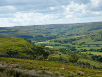 and across to the outward route through North Dale.

Eventually I arrived at Chimney Bank.

Somehow I missed the path down into the village and took the knee pounding 1:3 lane down the hill.

Today’s walk was my first decent walk for some time. It was very enjoyable. I averaged somewhat under 3 mph, including a couple of breaks, but did not have any serious foot problems. I experimented a bit with footwear and found that a Thorlos liner sock, worn only on my smaller right foot, under a pair of Thorlos Light Hiking socks was the most comfortable combination.
I tried my new Berghaus Freeflow rucksack, Thurlos flask and a Sigg water bottle, all bought en-route to Rosedale, and everything performed well. My Low Alpine dryflo briefs ensured that important little places remained comfy in what was fairly warm weather.
Milage: about 13 miles.
All things considered, not a bad day out.
 eting the C2C without some serious preparation. A day off with fair weather prospects saw me Rosedale bound to renew acquaintance with a favourite walk using the old ironstone railway. After gear shopping in Pickering, I eventually set out from Rosedale Abbey at lunchtime.
My route lead up the small tributary valley of North Dale.
After crossing the Bell Top ridge, I progressed through woodland, arriving back into Rosedale proper.


The walk joins the track bed of the old ironstone railway near the remains of mining activity at East Mines and co
 ntours northwards towards the dale head. It’s over eighty years since the mines and railway finally closed after years of decline. What must have once been tremendous scars on the valley are now gently melting back into the hillside and remain as interesting archeological and historical footnotes; impressive, but seemingly as remote from today as Hadrian's Wall.
Farming, however, is eternal…

The track bed deteriorates for a mile or so around the dale head and the landscape takes on a bleak and barren feel.
 The roads here cross the moorland plateau a couple of hundred feet above the course of the railway. Walkers, doubtless Coast to Coasters, could be seen walking on the road over Blakey Ridge, ignoring a perfectly good, marginally shorter path, across the dale head.
After passing a second track side ruined shed it was decision time: whether to visit the Lion Inn. In the event, I’d plenty of liquid and was running a little slower than anticipated, so I reluctantly plodded on.
I’d only met two pairs of walkers and a mountain biker before arriving at Blakey Junction, where the track nears the road. For twenty yards either side of the access track from the car park there was a veritable scrum of a dozen souls admiring the impressive views of the dale. A few paces later birdsong returned and only one further couple was met before Chimney Bank.
The miles to Chimney Bank go quickly, with little to divert one’s attention from the view until
 Sheriff’s Pit, a long abandoned mine. The shaft is said to be 250 foot deep and is protected only by a wire fence. The footings of buildings can be traced, but only a fragment of wall remains.
An alternative path, difficult to trace on the ground, but with an obvious course, leaves the pit to the hamlet of Thorgill. A mix of lane and path then provide a slightly shorter, but an arguably more varied, route back to Rosedale Abbey.

Whilst becoming a little tedious underfoot the main route doesn’t disappoint visually, with extensive views along the valley,


 and across to the outward route through North Dale.
Eventually I arrived at Chimney Bank.

Somehow I missed the path down into the village and took the knee pounding 1:3 lane down the hill.

Today’s walk was my first decent walk for some time. It was very enjoyable. I averaged somewhat under 3 mph, including a couple of breaks, but did not have any serious foot problems. I experimented a bit with footwear and found that a Thorlos liner sock, worn only on my smaller right foot, under a pair of Thorlos Light Hiking socks was the most comfortable combination.
I tried my new Berghaus Freeflow rucksack, Thurlos flask and a Sigg water bottle, all bought en-route to Rosedale, and everything performed well. My Low Alpine dryflo briefs ensured that important little places remained comfy in what was fairly warm weather.
Milage: about 13 miles.
All things considered, not a bad day out.
Progress check
Dates arranged: 4th to 17th of September 2008.
Accommodation: booked.
Packhorse: arranged.
Deposits: paid.
Weight: a shade under 15 stone (optimum weight about 14 stone).
Last day walk: can’t remember.
New gear:
1. A pair of Pacerpoles (bought largely as a result of a critique on a Lands End to John O'Groats blog (M & G Go for a Walk). The cheapest price I could find for a carbon fibre pair was from Kendal Sport. I was impressed by the service: an error was quickly resolved, with a pair of Thorlos liner socks thrown in by way of compensation.
2. A Berghaus Freeflow IV 25 Day Sack, a Sigg Water bottle and a Vango flask: all from Ryedale Rambler at Pickering. I called in at Pickering en-route to Rosedale for a walk and got the gear at the internet price – around 20% cheaper than shop price.
3. New Thorlos socks and Lowe Alpine Dryflo briefs.
Best get into shape or risk losing lots of brass.
Why the Coast to Coast?
I’ve walked the C2C route before. That was in September 1994. I did it again a few months later, in July 1995. On those occasions I walked with “our lass”. This time I’ll be walking alone.
The 1994 expedition was our first really big walk. We’d got into walking two or three years earlier with days out on the North York Moors, Yorkshire Dales and the Lakes. Then we tried the Dales Way in 1993 and were hooked on Long Distance Paths: the camaraderie and the progression through a gradually changing landscape were addictive. We quickly notched up the Westmorland Way, the Cumbria Way and, in bits, the local-to-us Wolds Way.
What the other paths offered, however, the C2C did too, but in buckets!
Since then Rita’s health has deteriorated somewhat and now precludes serious walking. I, however, continued hiking with friends and wandered along lots of northern Ways and Walks, notably a route based on John Gillham’s “Lakeland to Lindisfarne” book, the completion of Paul Hannon's trilogy of Lakeland walks (the Westmorland, Cumberland and Furness Ways) and the daddy of them all, the Pennine Way (2002).
Then I drifted away from regular outings and got fat…
Last year I got a grip: went on the wagon, adopted a fish and plant diet and bought new boots. I had three respectable outings in 2007, revisiting the Dales Way and Cumbria Way, and improvising a three day circular outing in the Yorkshire Dales linking Hawes, Kirkby Stephen and Keld.
All these walks were done solo. I wasn't sure if I could tolerate my own company for extended periods, but in the event I rather enjoyed the experience. Solo walking happens at one's own pace and preference, with the opportunity to drop in and out fellow wayfarers company, on the trail or in the pub, more or less at will.
There were a couple of problems though: feet. All three walks produced blisters. I’d used Brasher Supalite boots on the first two jaunts and concluded that they were fine for the occasional day walk, but not up to extended use. The replacement Meindl Atlanta boots were taken virtually untried to the start of the Cumbria Way at Ulverston and saw me limping for the bus home at the Old Dungeon Ghyll a couple of days later with world class blebs.
Another unwelcome development was a bout of sciatica over the winter months, and the Physio’s predictable advice that carrying a 25lb pack for a week or two over rough and undulating terrain was unlikely to help.
So, where to go in 2008? An attractive route, doable in a couple of weeks, with a bag transfer service – I know, I’ve always said I’d go again; I’ll do the Coast to Coast.
Subscribe to:
Posts (Atom)

