Sunday 31 August 2008

Bridlington, Bessingby, Wilsthorpe and Fraisthorpe (31/08/2008)

All things considered I decided to have a short morning walk from the front door today. Rain and thunder was forecast for later. There was also a lot to do at home on the last few days run-up to the start of leave from work on Thursday and beginning the C2C walk on Friday.

I and the dog set off into a sea-roke, heading through the outskirts of Bridlington to the old estate hamlet of Bessingby, before heading back to the coast at Wilsthorpe. Testifying to the lack of summer sun and a surfeit of rain the harvest is far from complete.

Despite having used these local paths frequently over the years for dog walking, and, in spite of there being plenty of evidence of use, I’ve seen more deer than people on the track between Bessingby and Wilsthorpe. Today was not an exception people-wise.

The cliff was a good bit busier with a camp at the Royal Yorkshire Yacht Club dingy club (there was some sort of event over the weekend) and a Caravan Club camp at Fraisthorpe. I kept to the eroding, low, glacial till cliff to Fraisthorpe, before dropping to the wonderful sandy beach and turning back north to Bridlington and home.

The mist never did clear, so no photos, but, as is often the case, it seemed not to penetrate too far inland.

Although this walk passes through or near urban housing, an industrial estate, sewage works, recycling plant, caravan site and holiday chalets, the walk is surprisingly pleasant, particularly on the beach at Fraisthorpe. It was a hot and humid seven miles, the last walk before my hols.


Monday 25 August 2008

North Wolds Walk (North): 25/08/2008


Posted by Picasa


Posted by Picasa


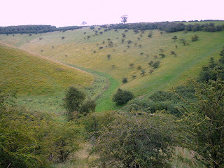
Unusually, I was out and about and walking, through Thixendale village, by 10:15. The weather was dull, but warm and dry. Today’s walk was loosely based on the northern segment of the North Wolds Walk, with the two legs linked, between Bishop Wilton and Wayrham, via the Manna Green open access area.

The walk began with a gradual ascent through a typical Wolds dry valley to Thixendale Grange, followed by a descent down the escarpment to Kirby Underdale. There are extensive views from the edge across the Vale of York, but, in today’s dullish weather, they didn’t extend quite to the Pennines.

I practically stepped on a leveret laid in its form in the rough pasture on the descent to Waterloo Beck, near Mount Pleasant Farm.

Rita was brought up in nearby Bugthorpe but, despite knowing the area well, I haven’t walked the local paths much. I hiked the Chalkland Way several years ago, which passes nearby, but the paths between Thixendale Grange and the Yorkshire Wolds Way at Bradeham Dale, were new to me. They don’t disappoint: it’s magnificent walking. Perhaps because of the scenic qualities hereabouts, the proximity to York and the fact that today is a Bank Holiday, plenty of other walkers were out and about.

Kirby Underdale is pretty, but was closed. Not a soul was to be seen or heard. The green lane up from Kirby to Garrowby Hill top, however, is a gem – a long, steep steady pull, with ever-widening views across the flat lands beyond. After defying death crossing of the A166, another entertaining path hovers over Bishop Wilton, before heading over the Wold top to Manna Green.

It’s 35 years or more since I was last at Manna Green. Rita’s father rented the dale to graze and condition cattle. My one and only shooting expedition was here. The dale at that time was overrun with rabbits (not a one showed today, so I must have been a pretty good hunter!). I remember taking careful aim with a .22 rifle and watching the poor creature sat six foot from my intended victim keel over dead. I still feel guilty. I’m afraid that if I’d got to kill my meat I’d have been a vegetarian years ago.

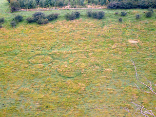
The dale is as bonny as I remember it – and the sides just as steep. The pull up from the dale bottom though is relentless. I was pleased to gain the top with just one photo break. Looking from the path across the dale there are a series of circles etched into the vegetation on the opposite slope. The dale is too steep to be cultivated, or for the marks to be traces of structures; the circles seem too perfect to be the result of natural growth(although some sort of fungal growth seems the most likely cause); nothing is marked on the map.

A quick skip back across the A166 at Wayrham deposited me in another system of dales, eventually meeting the Yorkshire Wolds Way, which accompanied me back to Thixendale.

Today’s walk was of about thirteen miles with plenty of ascents and descents. The circuit took about four hours, including a half hour refreshment break. I had no foot problems and was fresh enough at the end to have comfortably walked another five miles or more.

Sunday 24 August 2008

Fordon Circular (24/08/2008)


Posted by Picasa

I’d originally planned to walk a fairly challenging route in the Thixendale/Kirby Underdale area today – a chunk of the North Wolds Walk – but, by the time I got myself organised and through various chores, it was a little late to venture too far in the Bank Holiday traffic. I postponed the longer hike and settled for a toddle in the Fordon area – a repeat of a five mile walk I did at the back end of June.

By way of a contrast, this time I walked the circuit anti-clockwise. This had the advantage of getting the mile or so of road walking in East Dale done and out of the way at the start.

Someone had decorated the bridleway up to Danebury Manor with a couple of old ‘fridges – with no more effort they could have been taken to the amenity site. This desecration was matched by a large bag of builders’ waste, dumped at the side of Flixton lane. I bet the culprit was really proud of having avoided paying for proper disposal. Some people don’t deserve to be in business.

These grumbles aside the walk was again very pleasant (and litter free). Butterflies and birds were out in abundance, together with the odd rabbit.

On the descent into Lang Dale I had twin sightings of much rarer creatures; walkers on the Yorkshire Wolds Way. I chatted for a little while with two elderly men (i.e.: older than me), who were walking the route in stages. Resuming the descent into the dale I exchanged greetings with what looked like a mother and daughter backpacking the trail. The Wolds Way is underrated; perhaps it is less taxing than other long distance paths, but it truly is a very good walk.

After attacking the jungle of nettles and briars on the path into the farm yard at Fordon, it was back to the car and home.

Sunday 17 August 2008

Flamborough Head circuit (17 August 2008)

The morning was wet and windy – more like late September than mid-August. I was beginning to settle down to a lazy Sunday with the papers, but saw that the weather was forecast to improve in the afternoon: and so it did.
Because of the late start I headed to Flamborough to repeat the walk I did four weeks ago around the Headland. A jolly good walk it is too.
I didn’t have my camera with me today. I’m still waiting for number two son to return it following a trip he’d had to York.
The paths were wet and soggy, but quiet, away from the car parks. The rain stayed away with the afternoon proving warm and humid.
The afternoon featured sightings of most of the common butterflies: Tortoiseshells, Red Admirals and Painted Ladies. In addition to the usual seabirds I watched a Sparrow Hawk hunting along the cliff. I didn’t see any Gannets today though, and no mammals were around; I didn’t even see a rabbit.
The car park at North Landing is a litter-strewn mess. The lighthouse area seems somewhat better, but both attract too many slobs and people happy to picnic in the detritus of others’ slops. The cliffs, by contrast are generally pristine.
I varied the walk a little bit by trying a new (to me) permissive path along the eastern fringe of Dane's Dyke. The path shaved a couple of hundred yards off the distance, and steers clear of people and traffic.
I was pleased with today. In the month since I last did this ten mile walk my fitness must have improved. Whilst it’s difficult to be totally objective, I didn’t consciously alter my pace, but walked the circuit more quickly, with less effort and reduced fatigue.    
The circuit is a good walk by any standards, with plenty of interest, both out to sea and along the cliff, ever-changing views and an abundance of bird and insect life. Shame about North Landing…

Sunday 10 August 2008

Carnaby, Boynton, High Caythorpe, Rudston Walk


Posted by Picasa


Posted by Picasa

The weather was windy, changeable and frequently wet, so I opted for another local walk today. It’s one I could start from my front door but, to avoid wandering through town and not wanting to walk along the busy A614 road, I drove a couple of miles to begin at Carnaby.

I got kitted up just in time to catch the beginning of the promised rain. It accompanied me, on and off, all the way the High Caythorpe.

I passed Carnaby Temple, an 18th century folly, and walked through Boynton, with its Hall and church, before taking the lane towards Grindale.

I optimistically decided to use a route to High Caythorpe marked on the map as an “Other Routes with Public Access”. As I’d feared, the route did not exist on the ground. I had to improvise a course, following field edges and rough tracks, before eventually joining a bridleway, which brought me to the farm at High Caythorpe. In this process I got thoroughly wet and muddy: but at least the weather was improving.

On the way to Rudston, now in grand Wold country, I caught sight of a fox running across the track.

I took a breather in the churchyard at Rudston, after reacquainting myself the impressive monolith, the tallest standing stone in the UK and the centre of an extensive system of earthworks. A family wandered into the yard: they sensibly give a wide birth to the suspicious, scruffy, mud-stained old tramp, sat barefoot, scoffing fruit and swigging coffee.

An attractive path leads out of the village, through woodland, gaining height to meet the Woldgate Roman road. Another “Other Route with Public Access”, this one extant, leaves Woldgate, dropping through large arable fields with wide ranging views over Holderness, to eventually join a lane just outside Carnaby.

The walk was eleven miles or so. Despite the weather it was very enjoyable and full of historical interest. It’s all too easy to drive miles for a walk whilst ignoring the countryside on one’s doorstep. I didn’t see any other walkers out today, but saw plenty of evidence of path use - muddy boot prints aplenty.

Tuesday 5 August 2008

Bessingby, Wilsthorpe Walk


Posted by Picasa


I took leave today: we’ve got the builders in making a conservatory. I had a couple of hours spare to fit in a short afternoon stroll in the rain with the dog. The advantage of today’s route was that it began and ended at my back door.

After passing through a housing development, an industrial estate, allotments and playing fields, the scene becomes quite rural. I went first to Bessingby, an old estate village. The path then heads for the A165 and the cliff at Wilsthorpe (caravans, chalets and small farms) using overgrown, wet tracks and quiet back lanes.

I’d intended walking along the cliff (here a low clay affair) down to Fraisthorpe and back on the beach, but the dog was looking distinctly soggy and the rain looked set for the rest of the day. We headed for home.

The walk was about five miles.

Sunday 3 August 2008

Hutton-le-Hole, Rosedale, Lastingham, Spaunton Walk (03/08/2008)


Posted by Picasa


Posted by Picasa


I had an early (for me) start. I had driven the forty miles or so to Hutton-le-Hole and was on Spaunton Moor before eleven: just in time to be soaked in a heavy shower. The heather was just beginning to flower; adding interest to what can be a bleak scene.

I had intended to take a beeline over Access Land, from the point where the trail meets the Rosedale road, to visit Anna Cross. Whilst the cross is quite close, I retreated from the attempt, driven back to the road after floundering in rough and boggy ground.

Chimney Bank was busy with car and cycle borne visitors and a smattering of other walkers. I took the old sled way, associated with long gone iron stone mining, down into Rosedale. The track gets lost in a jungle of bracken in the lower section of the descent at this time if the year but the course is obvious, if a little awkward.

I joined a bridleway which took me downriver. It is a glorious trail through the moor and bracken, staying well above the western bank of the River Seven. The eastern side is thickly forested with the road hidden from sound and view. There were plenty of rabbits about, but I’ve seen deer and a fox in this area on previous visits.

The path passes the site of an Elizabethan glass works, marked by a plaque. A reconstruction of the works can be seen at the Ryedale Folk museum at Hutton-le-Hole. To the untutored eye, however, there's nothing much to see. Like the ironstone industry the remains have melted back into the landscape. It is fascinating to consider, though, that this lonely and peaceful spot was a hive of industry in the sixteenth century and that the whole dale, surely one of the most interesting and scenic of the Moors valleys, was riven by mining and industry up until less than a century ago.

Just beyond Hartoft I left the bridleway to take the Lastingham path over the moor and into the village. Lastingham is a pretty village with a good pub and a fascinating church. I visited neither, but took the steep woodland path up the Tabular Hills escarpment and on into Spaunton.

The geology of the Tabular Hills is limestone, as distinct from the sandstone and shale of the moors. The land is sweet and productive, growing barley and wheat at a similar elevation to much of the lower moorland. The contrast is complete and sudden. From a walker’s viewpoint, however, the interest around Spaunton is entirely in the view across to the moors.

Hutton-le-Hole had got busy whilst I’d been away. Fortunately most don’t wander too far from the cafes and pub and Folk Museum. There had been others walking and some mountain biking, but, for the most part, I’d had the paths to myself.

The walk was about eleven miles, including my aborted attempt to visit Anna Cross, and was mainly on good moorland tracks, but with added interest from a couple of wooded sections. It presented no fitness, foot or stamina problems. I should be increasing mileage on my walks though; the C2C is only a month away.