 eting the C2C without some serious preparation. A day off with fair weather prospects saw me Rosedale bound to renew acquaintance with a favourite walk using the old ironstone railway. After gear shopping in Pickering, I eventually set out from Rosedale Abbey at lunchtime.
My route lead up the small tributary valley of North Dale.
After crossing the Bell Top ridge, I progressed through woodland, arriving back into Rosedale proper.


The walk joins the track bed of the old ironstone railway near the remains of mining activity at East Mines and co
 ntours northwards towards the dale head. It’s over eighty years since the mines and railway finally closed after years of decline. What must have once been tremendous scars on the valley are now gently melting back into the hillside and remain as interesting archeological and historical footnotes; impressive, but seemingly as remote from today as Hadrian's Wall.
Farming, however, is eternal…

The track bed deteriorates for a mile or so around the dale head and the landscape takes on a bleak and barren feel.
 The roads here cross the moorland plateau a couple of hundred feet above the course of the railway. Walkers, doubtless Coast to Coasters, could be seen walking on the road over Blakey Ridge, ignoring a perfectly good, marginally shorter path, across the dale head.
After passing a second track side ruined shed it was decision time: whether to visit the Lion Inn. In the event, I’d plenty of liquid and was running a little slower than anticipated, so I reluctantly plodded on.
I’d only met two pairs of walkers and a mountain biker before arriving at Blakey Junction, where the track nears the road. For twenty yards either side of the access track from the car park there was a veritable scrum of a dozen souls admiring the impressive views of the dale. A few paces later birdsong returned and only one further couple was met before Chimney Bank.
The miles to Chimney Bank go quickly, with little to divert one’s attention from the view until
 Sheriff’s Pit, a long abandoned mine. The shaft is said to be 250 foot deep and is protected only by a wire fence. The footings of buildings can be traced, but only a fragment of wall remains.
An alternative path, difficult to trace on the ground, but with an obvious course, leaves the pit to the hamlet of Thorgill. A mix of lane and path then provide a slightly shorter, but an arguably more varied, route back to Rosedale Abbey.

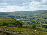
Whilst becoming a little tedious underfoot the main route doesn’t disappoint visually, with extensive views along the valley,


 and across to the outward route through North Dale.
Eventually I arrived at Chimney Bank.

Somehow I missed the path down into the village and took the knee pounding 1:3 lane down the hill.

Today’s walk was my first decent walk for some time. It was very enjoyable. I averaged somewhat under 3 mph, including a couple of breaks, but did not have any serious foot problems. I experimented a bit with footwear and found that a Thorlos liner sock, worn only on my smaller right foot, under a pair of Thorlos Light Hiking socks was the most comfortable combination.
I tried my new Berghaus Freeflow rucksack, Thurlos flask and a Sigg water bottle, all bought en-route to Rosedale, and everything performed well. My Low Alpine dryflo briefs ensured that important little places remained comfy in what was fairly warm weather.
Milage: about 13 miles.
All things considered, not a bad day out.


No comments:
Post a Comment